Contact us today.
Why land south of the railway line, Riddells Creek
All the townships within the Macedon Ranges Shire Council have defined future development areas, including Riddells Creek. A Statement of Planning Policy, forming part of the Macedon Ranges Planning Scheme, defines where townships can and can’t grow.
What is a “Township Boundary”?
It defines the ultimate area for a township and where it can accommodate future anticipated growth. If towns do not have a defined boundary, it has been determined to have no further urban development (no zoning changes to urban uses).
The southern growth area (south of the railway line) is made up of one large and several smaller properties, creating land south of the railway line, Riddells Creek:
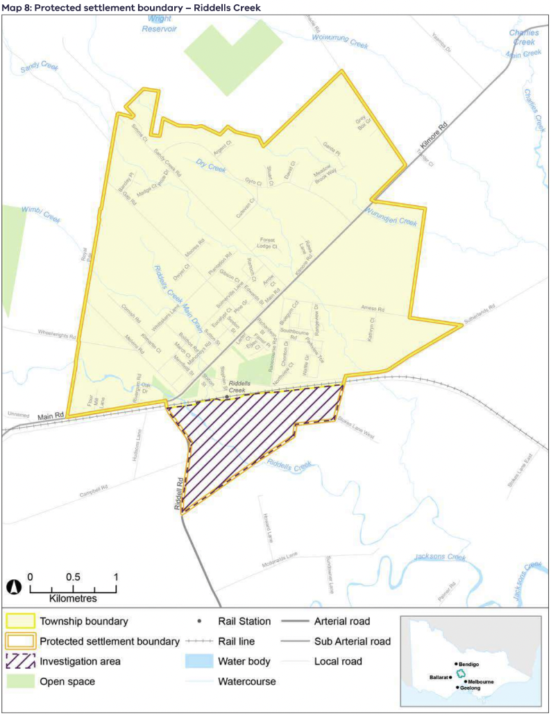
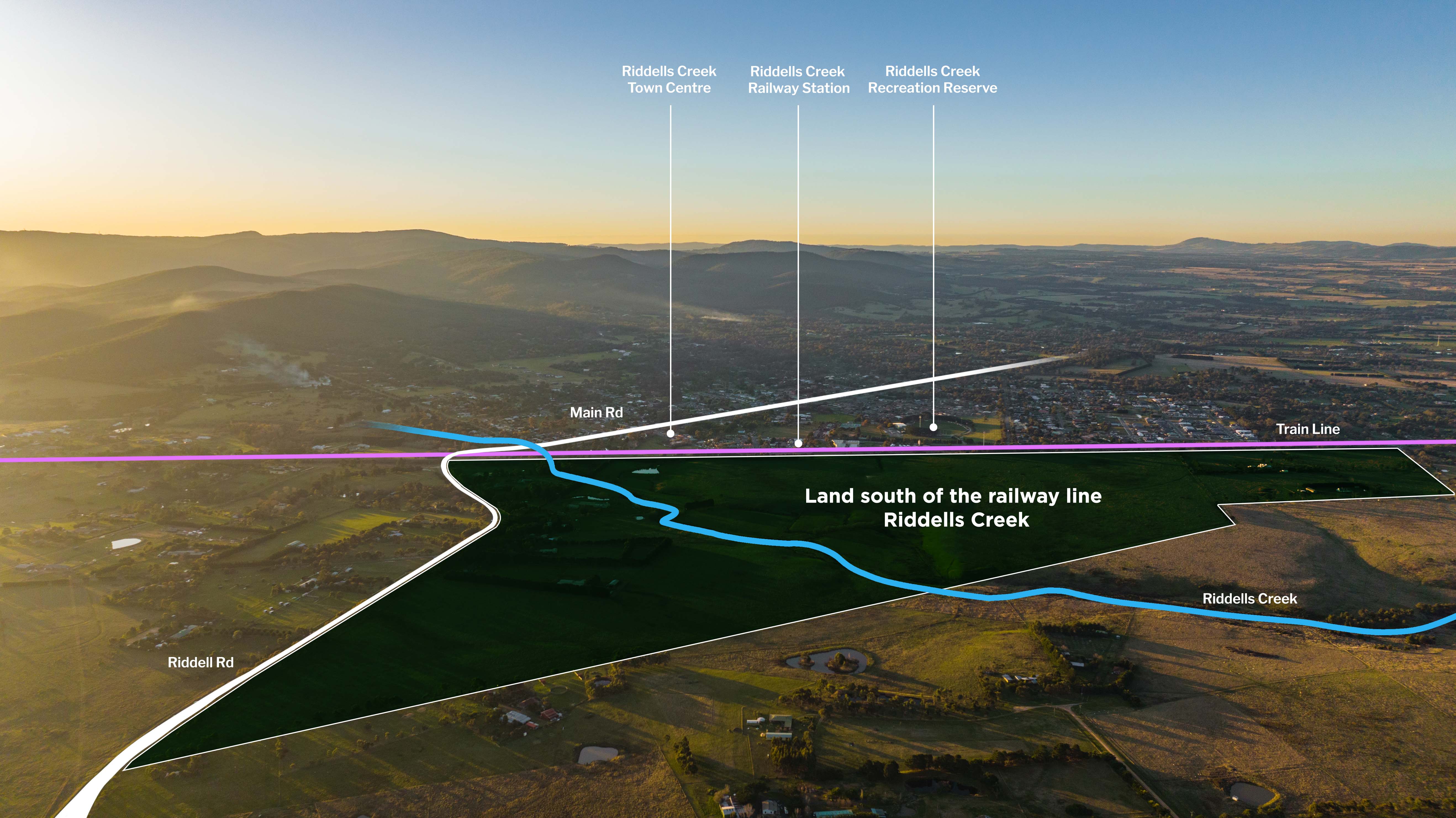
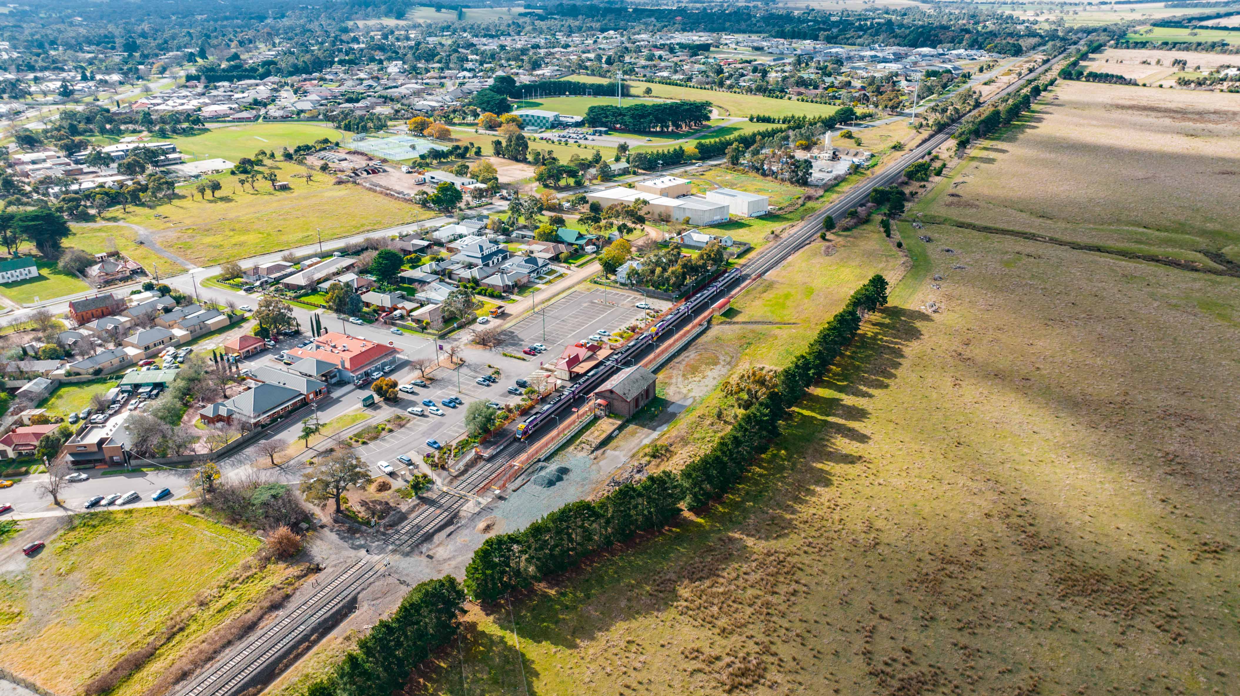
This southern area is referred to as land south of the railway line, Riddells Creek and will one day provide growth opportunity for the town. It is close to the railway station and town centre and can provide an alternative access and exit
point to Riddells Creek via a link road between Sunbury Road and Sutherland Road.
Once a township boundary is defined, there are advantages to planning (within existing Riddells Creek
and future development areas) including:
– a single long-term plan for Riddells Creek
– an approximate estimated population number
– enabling planning for community services such as educational facilities, community facilities,
retail facilities, health services, and sports spaces
– enabling the delivery of consistent principals for new development including lot sizes, design
principles for open space, streetscapes and natural feature protection. This includes parks,
walking and cycling paths and integration of open space.
Completing planning for the township will deliver a complete plan for Riddells Creek, enabling a
considered approach to the long-term design of the town, delivering long term certainty, and alleviating concerns as to what could occur.
What land is included in land south of the railway line, Riddells Creek?
This land directly south of the Riddells Creek train station (136.5 hectares) is limited to the 10 properties located inside of the Settlement Boundary, as defined by the Riddells Creek Structure Plan and Statement of Planning Policy. This includes 97 hectares of land owned by Spacious Group.

Planning process
For a plan to be developed, there are three essential phased steps:
1. Preparation of Land south of the railway line, Riddells Creek Plan
Design and confirmation of what the town should look like, including housing types, open space provision, transport network, community facilities etc. This would also include identification of the important elements of a plan and a clear set of requirements for any changes in land use. The Plan can apply to the whole township or specific areas within the town.
2. Recognition of the plan in the Macedon Ranges Planning Scheme
For a plan to be binding, it must be recognised in the Macedon Ranges Planning Scheme. Recognition can happen through several mechanisms:
a) a planning policy,
b) a Precinct Structure Plan that forms part of the planning scheme
c) or a development plan, through a Development Plan Overlay provision being written into the scheme.
All options would require a Planning Scheme amendment and a public consultation process.
3. Planning Permit
Once the Macedon Ranges Planning Scheme recognises a plan to direct future development of land, a planning permit needs to be issued by Macedon Ranges Shire Council and any permit would need to be consistent with the Macedon Ranges Planning Scheme provisions including the detail of any approved Plan.
Timeline
What’s Happened to Date
September 2013
Riddells Creek Structure Plan is completed.
June 2017
Amendment to the Macedon Ranges Planning Scheme to implement the Riddells Creek Structure Plan.
2018
Spacious Group purchased 10 Daffodil Lane.
December 2019
Macedon Ranges Statement of Planning Policy is endorsed.
Late 2021
Technical Investigations undertaken (Flora, Fauna, Bushfire, Heritage, Geotechnical and more)
May 2022
Meetings with Council to notify of our intention to engage with the community.
August to October 2022
Phase one engagement: 163 people participated including 108 surveys completed, 35 people attending a workshop and 20 webinar attendees. Participants were asked to share what they value about Riddells Creek, their vision for the site, community facilities, housing, lot sizes, neighbourhood design and parking they thought should be included in the site, and potential design principles to guide the development of the site. Additional feedback was also provided. Go here for the Phase One engagement report.
April 2023
Briefing to the Macedon Ranges Shire Councillors following Phase One engagement. The briefing included a presentation covering why the engagement occurred, and an overview of the engagement process and results. Following the presentation, Councillors had the opportunity to make comments and ask questions of the project team. Go to here for the Councillor Presentation Summary Report 2023.
October to November 2023- WE ARE HERE
Phase two engagement: Following Phase one engagement and Councillor feedback, we have conceptualised what we heard into the ‘Response to community feedback report’. We want to hear your feedback, ideas and suggestions to the report which includes a Draft Response Plan, vision statement for the site and draft street cross sections.
To find out more and complete the online survey, go to the get involved page.
Community Engagement
July 2022
Website Launch.
August to September 2022
Phase one engagement.
October 2022
Review Feedback and Development Concept.
October to November 2023
Phase two engagement: Current community engagement.
Technical investigations and background studies
To ensure a sustainable and appropriate plan for the future, it is important to gain a thorough understanding of the area, and what currently exists on the land through technical investigations and background studies.
Studies undertaken or occurring include:
- Traffic and Transport Due Diligence Assessment (complete)
- Preliminary Flood Assessment (complete)
- Feature and Level Survey Plan (complete)
- Population Forecast Analysis (complete)
- Preliminary Site Investigation Report (complete)
- Preliminary Cultural Heritage Review (complete)
- Flora and Fauna Assessment (complete)
- Bushfire Risk Assessment (complete)
- Servicing Report (complete)
- Targeted Biodiversity Surveys (2024)
- Complex Cultural Heritage Assessment (ongoing)
Background plans
Riddells Creek Structure Plan 2013 (RCSP) (Click to download pdf)
The Structure Plan identifies a range of policy directions for development within the existing township, urban design directions and directions for the management of public realm. It also nominates two growth areas, north and south. It was the Structure Plan that informed the township boundaries within the Statement of Planning Policy.
The only decisions made so far are:
1. Extent of the settlement boundary (these are defined by MRSC(Macedon Ranges Shire Council) and DELWP(Department of Environment, Land, Water and Planning) through the Structure Plan and Statement of Planning Policy and will not be altered).
2. Protection of Riddells Creek and adjoining vegetation / habitat for ecological and cultural heritage purposes.
Macedon Ranges Statement of Planning Policy 2021 (MSRC) (Click to download pdf)
This plan relates to the whole municipality. It establishes a range of policy directions for environmental protection, catchment protection, farming, tourism management and identifies township boundaries and limits to growth.
Observations of Macedon Ranges towns and Riddells Creek
Macedon Ranges Townships have their own individual characteristics including:
- Wide streets
- Influenced by views to the surrounding country
- Cool climate plantings in public spaces and streets
- Mt Macedon being dominant from the south.


Our observations of Riddells Creek include:
- Wide streets
- Grassy verges
- Street trees
- Residential Lots of around 800 sqm to 1200 sqm
- Open space and natural habitat along Riddells Creek, including provision of walking and cycling paths
- Vistas and long views to Mt Macedon
- Exotic street tree planting
Riddells Creek residential buildings:
- Typically detached or situated on large lots
- Front and side setbacks
- Traditional materials, reflecting the heritage and rural character of the town.


